The Cley Bird Club monitors and reports on birds within the ‘Cley Square’. This is defined as the 10Km Square with OS Grid Reference TG04. It covers the area of the North Norfolk coast from Morston in the west to Kelling in the east. The southern boundary is between Langham and Field Dalling at the western end and just north of High Kelling in the east. It includes the Bayfield estate but not Letheringsett, Holt or High Kelling. We do include an extension to the west to cover all of Blakeney Point. The boundary to the east passes through Kelling Heath but we are interested in hearing about all sightings from there. The northern boundary is out to sea and all birds viewed from the coast are considered as in the Square.
You can download and print a pocket-sized leaflet ‘Checklist and Recording Area Map’ for your own use.
A full list of all birds seen in the area with details of some can be accessed from the ‘Records’ tab above.
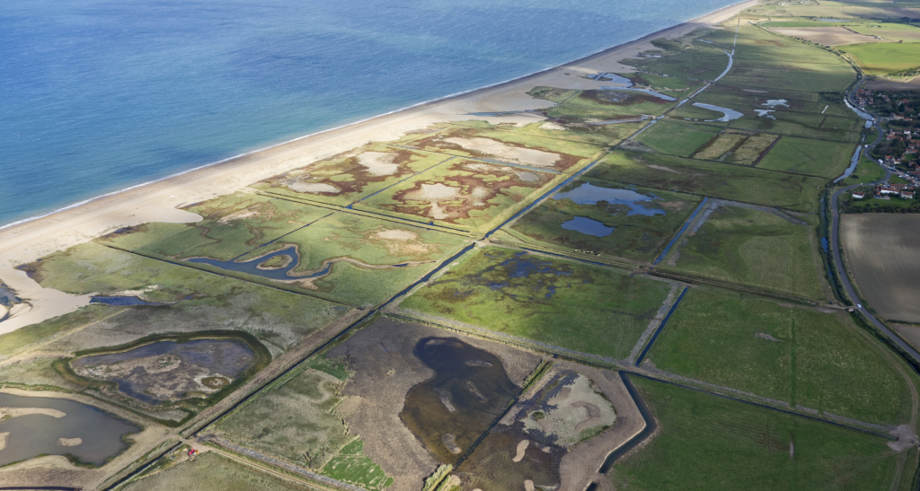
The map below (updated June 2020) shows the area covered and the location of sites detailed below.

The above map can be enlarged by clicking on it, then clicking on the zoom sign at the top right-hand corner. Clicking again and closing it gets you back to this page.
If you would like to download a printable copy click here.
Blakeney National Nature Reserve
Blakeney Point
A shingle spit west of Cley owned by the National Trust, comprising vegetated shingle, saltmarsh and sand dunes. It is a 3½ mile walk from Cley Beach car-park to the Point or it can be accessed by boat from Morston Quay at high tide. Read More
Blakeney Harbour
An area of tidal saltmarsh and open water enclosed by the Point. Read More
Morston Quay
Situated to the north of Morston village off the A149, the National Trust information centre is situated here together with a large National Trust run car-park (free for NT members). Boat trips run from here to see the seals and terns on Blakeney Point. Read More
Blakeney Quay
Situated to the north of Blakeney village off the A149. Another large National Trust car-park (free for NT members) gives access to the Harbour, the Coast Path and Blakeney Freshes. Read More
Blakeney Freshmarsh and Friary Hills
Also known as The Freshes or Blakeney Grazing Marsh (GM) this is an area of marsh east of Blakeney Quay enclosed by the sea wall and the Norfolk Coast Path. Read More
Cley & Salthouse area
Cley & Salthouse Marshes Norfolk Wildlife Trust (NWT) Reserve
This covers the area north of the A149 between Cley Beach Road and Kelling. It consists of fresh water scrapes, brackish lagoons and grazing meadows. There is an east-west channel across the length of the area which enables water to run off the reserve into Blakeney Harbour. The area south of this is freshwater and to the north is brackish with lagoons which are partially tidal. At the northern edge is a wide shingle beach which used to be maintained as a high tidal bank by bulldozing it but since 2007 this has been left to self-profile.
To the south of the A149 you will find the NWT Visitor Centre where you can purchase tickets to the reserve, get information about what is being seen and have elevated views across the reserve while drinking coffee and eating snacks or meals from the excellent café. The centre opens from 10am to 5pm in the summer months and 10am to 4pm in the winter. Various events and guided walks are held in, and from, the Simon Aspinal Education Centre and details about these and more information on the reserve can be found on the NWT Cley and Salthouse Marshes website
For convenience we have split the area into three parts:
1. Cley Beach Road to East Bank
This area was the original NWT Cley reserve purchased in 1926. It comprises reedbed, fresh-water scrapes, dykes and grazing meadows in the southern half with brackish lagoons and shingle in the north. Read More
2. East Bank to Iron Road
Much of this area was purchased by the NWT in 2012 to join the Cley and Salthouse Marshes reserves and make a single coastal reserve of more than 300 hectares. It is made up of wet grazing marshes and reedbed. Read More
3. Salthouse Marshes
The area north of the A149 forms an eastward continuation of the grazing marshes of Cley and much of it is owned or managed by the NWT. Unfortunately, following the tidal surge of December 2013 the Beach car park no longer exists but there is limited parking on Beach Rd. South of the A149 there are arable fields stretching up to the ridge between Walsey Hills, Sarbury Hill and Salthouse village. Read More
Cley Village
Away from the reserve there are still other spots where birds can be found. The fields rising above the NWT Visitor Centre, gardens in the village and the northern end of the Glaven Valley have all been known to have good birds. Read More
Salthouse Heath
An area of heath and scrub on the ridge to the south of Salthouse. Read More
Walsey Hills
This site, owned by the Norfolk Ornithologists’ Association is situated south of the A149 just east of Cley East Bank. It is an area of gorse, mixed scrub and woodland. Read more
Kelling Area
Kelling Water Meadow and Quags
This, at the eastern end of the Square, covers the area in the parish of Kelling north of the A149 and west of Weybourne Camp and Muckleburgh Hill. Read More
Kelling Heath
This is a site of special scientific interest (SSSI) of approximately 220 acres of well-managed acid heathland on the eastern edge of the Cley Square, south of the A149. Read More
Wiveton & Glandford Area
Wiveton & Glandford
These two villages lie on the River Glaven. Rising from tiny headwaters near Bodham it descends wooded hills of glacial debris and passes through lush countryside and picturesque flint villages, before flowing into Blakeney Harbour. Within our area it passes through the Bayfield Estate forming the lake and then continues via Glandford Ford towards Cley where it flows under the A149 at the sluice just west of Cley. The meadows alongside it sometimes flood in winter. Read More
Wiveton Downs
This is a site of special scientific interest (SSSI) and a local nature reserve of both geological and wildlife interest. The site is elevated above the surrounding countryside giving excellent views over the village of Wiveton and the North Norfolk Coast, an area of outstanding natural beauty. Situated on the south end of the Blakeney Esker, a sand and gravel ridge that is here heathland with heather, gorse and bracken. Read More